AirMap, works all over the world and works in partnership with DJI. In some cases where legal, you can even use it to electronically notify the local airport of your flight plan. It will tell you if it is safe to fly, and what the phone number is for a tower if you need to call.
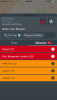
It shows you which areas are completely off limits ( military bases, National Parks), and will also show you local fly for fun rules and temporary flight restrictions. For example, I opened the app the other day, and in addition to the yellow circles normally around the local airports, I saw a red circle indicating temporary flight restrictions as low flying aircraft were practicing for an upcoming air show. Another time, in a place that is typically legal to fly, it showed temporary flight restrictions due to a national sporting event. Where I’m seated now... well see for yourself... it isn’t a good place to fly, lol. Apps don’t negate our personal responsibility to due our own diligence, but I really like this app, even if the result is, “NO YOU CAN’T FLY THERE!!!” Lol


")